What are movement monitoring surveys?
Movement monitoring is a broad term to describe various surveys that monitor change in buildings or ground over time. It is natural for ground, buildings and structures to move slightly over long periods. However, they may need to be measured, recorded and monitored when potential risks have been identified.
We can monitor building and ground movements for any change over time with a high degree of accuracy. This usually happens when specific activities, such as mining or construction works, have been identified as a risk to ground levels and existing buildings. Our monitoring systems can offer an early indication of potential problems or disprove any suspected movement or damage.
Where there is evidence of more significant movement, it may cause concerns for structural safety or land stability. As a result, the size of the movement and the pace of the changes may need to be monitored.
Where movement has been identified as a potential issue, our deformation and monitoring surveys are used by structural and geotechnical engineers for assessments. They will specify whether the area or structure needs short or long-term movement and deformation monitoring.
Engineers can use monitoring solutions for various reasons.
- Advising on damage to a structure following a climate event or accident
- Analysing and understanding the behaviour of a structure
- Extending the service life of structures and making maintenance cost-efficient
- Managing the sustainability and resilience of assets
Where could a monitoring survey be needed?
Typical uses
Why choose Cheshire Surveys
We provide a range of surveys and related services across the North West, Cheshire, North Staffordshire and North Wales.

Passion & technical expertise

25+ years experience

Quality services tailored to your project

Meet our team on site
Why are movement monitoring surveys needed?
Ground Movement Monitoring
Ground movement monitoring can be needed around construction sites with large excavations or heavy groundworks. It can check for any impact on the site’s surrounding land as well as on reclaimed or restored land where there is evidence of sinking or slippage.
Our previous projects show the various ways ground movement monitoring can benefit projects.
Monitoring land around the proposed quarry both before development started and once operations had begun. This ground monitoring enables us to record whether changes to the water table have caused any ground level movements.
Quality control for ongoing operations where activities may impact surrounding ground levels.
Slopes are monitored where there is evidence of slippage or movement that could cause danger to the environment or people. Engineers can use this data to recommend protective measures.
Evaluating the stability and strength of reclaimed ground by recording the ground level changes during load testing.
Areas with subsidence or those showing significant level changes, such as sinking footpaths or roads, can need ground monitoring. This will provide more detailed information about the changes to inform any resolutions.
Structural Health Monitoring
Structural monitoring solutions are normally required to monitor buildings and structures at risk of damage or changes. They also monitor for any changes in defects that have already been identified. These can range from cracks in houses or public buildings to changes in historic properties or structures.
Some construction works have the potential to cause damage or changes to nearby buildings and features, either on or near to the construction site. Monitoring these structures enables their structural health to be assessed during the lifetime of the build. The construction company must submit a record of the monitoring as the build progresses.
Structural health monitoring has a wide range of uses and our previous projects demonstrate some of these.
Monitoring foundations after installation to check they can withstand the load that will be built on top of them.
Where risks have been identified we can monitor for any changes to RAAC. It is usually found in ceilings and roof structures, especially for flat roofs, in public and commercial buildings.
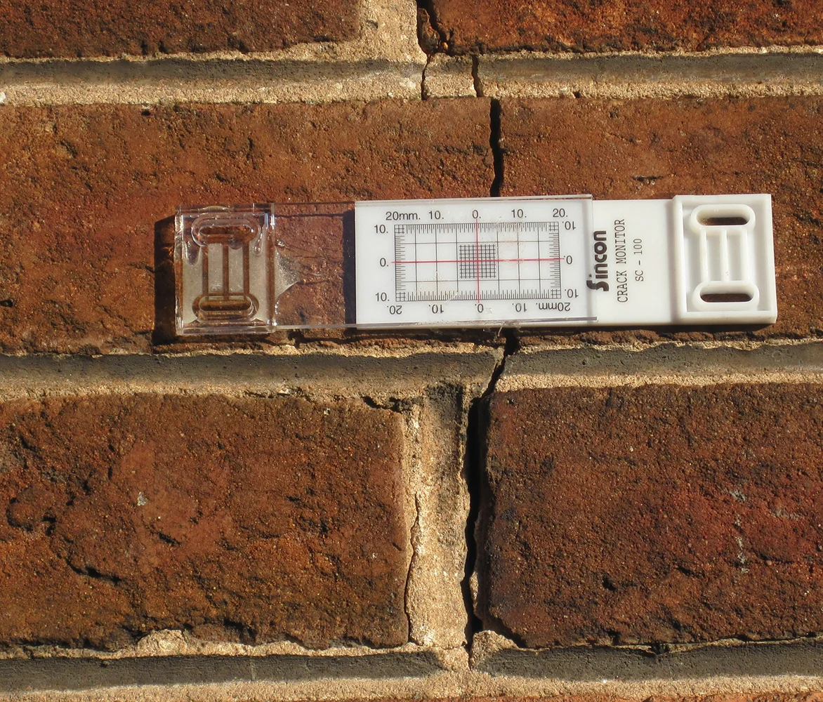
Monitoring the size of defects that have been identified already and are thought to be getting worse. Deformations in a building or structure might include cracks, leaning, bulging and bowing.
This structural monitoring can provide reassuring evidence that a nearby project is causing no damage to a particular feature.
Checking for movement or changes in the structure. E.g. monitoring an historic bridge during adjacent civil engineering or structural works.
How do we carry out ground and structural movement monitoring surveys?
We perform movement monitoring surveys using a total station and permanent markers. These enable us to record changes to position and level to the mm.
Our methodologies are bespoke for each job. We agree this, the overall timeframe and the visit schedule upfront to ensure the data will provide what you need.
Ground movement monitoring
Our ground monitoring is achieved using highly accurate permanent ground markers (PGMs). They provide a permanent reference location for ongoing monitoring of a specific location. They are installed much deeper in the ground than a standard survey control and can be used for long periods.
They allow for repeatability of results as the northings, easting and height can be recorded each time at the agreed intervals (e.g weekly, monthly, bimonthly, annually). You can compare the results from each interval and they will show changes down to the mm.
We can present movement monitoring data in various ways, depending on how you plan to use it.
- Cross section drawings
- Marker monitoring maps
- Easily see the position of the monitoring points with reference plans that show their locations
- Spreadsheet comparisons
- View all the measurements from each visit, including comparisons of the latest visit, the previous visits and the very first visit. This builds up a long-term picture and will highlight any sudden changes or patterns in the data.
- Visit 1 – Installation of monitoring devices and survey control
- We set up the monitoring devices and carry out a baseline survey of the positions.
- Visit 2 – Check survey to complete baseline data collection
- We’ll carry out a second visit soon after the installation. We’ll check that the monitoring devices are working correctly and note any anomalies or issues. This provides two sets of data that make up the baseline position for future monitoring. Depending on what we are monitoring, this visit could be 1 week, 2 weeks or 1 month after the first visit.
- Future Visits – Long-term movement monitoring
- We’ll make future visits at agreed intervals and for an agreed length of time. Visits may be monthly, bimonthly, six-monthly or annually. Some projects may only last for a few months, while we will support others for several years.
What happens if movement is detected?
Movement monitoring surveys provide robust and accurate data that can be analysed by experts in the movement of land or buildings. As land surveyors, we cannot advise on the results of any movement monitoring surveys. Instead, we work closely with structural and geotechnical engineers to provide them with detailed information.
An engineer will analyse and report back on the monitoring results, and recommend the appropriate next steps.
Structural monitoring
For our structural health monitoring we install permanent markers on the building or structure. We take measurements at regular intervals using a consistent methodology. The structural engineer will advise how long we need to monitor.
The type of marker used depends on what needs to be monitored. For example, we use specialist monitors to measure changes in cracks in walls or nails, while targets can be used to monitor level changes.
We can present movement monitoring data in various ways, depending on how you plan to use it.
- Cross section drawings
- Marker monitoring maps
- Easily see the position of the monitoring points with reference plans that show their locations
- Spreadsheet comparisons
- View all the measurements from each visit, including comparisons of the latest visit, the previous visits and the very first visit. This builds up a long-term picture and will highlight any sudden changes or patterns in the data.
- Visit 1 – Installation of monitoring devices and survey control
- We set up the monitoring devices and carry out a baseline survey of the positions.
- Visit 2 – Check survey to complete baseline data collection
- We’ll carry out a second visit soon after the installation. We’ll check that the monitoring devices are working correctly and note any anomalies or issues. This provides two sets of data that make up the baseline position for future monitoring. Depending on what we are monitoring, this visit could be 1 week, 2 weeks or 1 month after the first visit.
- Future Visits – Long-term movement monitoring
- We’ll make future visits at agreed intervals and for an agreed length of time. Visits may be monthly, bimonthly, six-monthly or annually. Some projects may only last for a few months, while we will support others for several years.
What happens if movement is detected?
Movement monitoring surveys provide robust and accurate data that can be analysed by experts in the movement of land or buildings. As land surveyors, we cannot advise on the results of any movement monitoring surveys. Instead, we work closely with structural and geotechnical engineers to provide them with detailed information.
An engineer will analyse and report back on the monitoring results, and recommend the appropriate next steps.
Speak to our experts
Get free advice or a quote from our experienced team.
We’re known for our reliable, quality service and attention to detail.
Cost of a ground movement or structural monitoring survey
Each movement monitoring job is unique so we price each job individually.
As an example, one or two cracks on the external wall of a house will usually be monitored for between 18 months and 2 years. With monthly visits, the cost could be £2000 – £3000. Ground monitoring on the outskirts of a new quarry with quarterly visits could cost up to £10,000 per year.
When we’re unable to offer monitoring services
There is some ground movement and structural monitoring that we cannot support, unfortunately. This includes jobs with highly specialised requirements or very specific tolerances. We’re also unable to carry out monitoring in locations that need to be serviced by professionals with specialist health and safety training or qualifications. We will always let clients know at the quote stage if this is the case.

How we work
 Step 01
Request a quote
We’ll need your project’s address and a site plan. We’ll then get in touch for a consultation to confirm site details and understand exactly what your project needs.
 Step 02
Quote accepted
Once your project is confirmed with us, we’ll arrange a convenient date for your survey.
 Step 03
We complete your survey
We’ll visit your project site to carry out the survey. We can meet you on site if needed. We will then process the survey data and create a survey drawing.
 Step 04
Receive your survey
We’ll share the survey data with you, usually within a few days. We use industry standard file types and can issue all the drawings in multiple formats.
Who we work with


More surveys we offer
 Topographical Surveys
Accurate, scaled plan of a site’s terrain, and a record of the position and levels of both manmade and natural features.
Measured Building Surveys
3D site survey of a building’s layout and structure that can also be used to produce floor plans, elevations and cross-section drawings.
As-Built Surveys
A fully up-to-date record of what has just been constructed, ensuring it matches the proposed plans. Useful for producing further plans that require an accurate site layout.
Boundary Surveys
Clearly understand your boundary lines, remove uncertainty around neighbouring land, and prevent disputes.
Floor Level Surveys
Quality survey check for various floor construction stages, from existing floors to newly constructed slabs.
Garden Surveys
Highly detailed, specialist topographical survey for garden landscaping and redesigns.
GPS Surveys
Ideal for covering large open spaces, like fields, or where access may be restricted or challenging.
Ground Investigation Services
Reliable and accurate location data for ground investigations like CBR tests, boreholes and trial pits. We record data and mark out investigation and monitoring points.
Movement Monitoring Surveys
Tracking and recording movement or alterations, such as crack monitoring and land movements, in either a built structure or a landform.
River & Floodplain Surveys
Surveys of riverbanks and beds, as well as adjacent floodplains. We record water levels and significant features for flood risk assessments and erosion monitoring.
Road Surveys
Comprehensive record of current road layouts and levels, including kerbs, street furniture and road markings. Ideal for visibility splays and new highways designs.
Setting Out
Geocordinated setting out services for building groundworks and steelworks for new housing, commercial and industrial sites.
Surveys for Land Registry Title Plans
Site surveys for creating Land Registry compliant plans to record areas of sale, transfer, correction or first registration.
Volumetric Surveys & Terrain Models
Measuring the total amount of stockpiled, extracted or collected materials and aggregates. Suitable for construction, calculating and auditing.


